Surprise! Accessing That Newly Noticed Beach in Downtown Sag Harbor
There’s a plan afoot in Sag Harbor to open a second beach in the middle of town. The first beach, Windmill Beach, was created about 20 years ago when the Village Trustees decided to put a little sand next to the town windmill at the foot of Long Wharf. It’s a great place to lay out a blanket, put up an umbrella and look out at the bay in the middle of a hot summer’s day. In the back, several park benches sit on a lawn looking out. With a little planning, it’s possible to arrange a morning of shopping and sightseeing, a picnic lunch at the beach, and then more of the same in the afternoon.
Now it turns out there’s a way to greatly expand on this wonderful little beach project. It involves very little expense, just the building of a broad new 150-yard walkway. It would lead to a little known and almost secret beach, which, for those few who know about it, is simply the best place to watch the sunset in town.
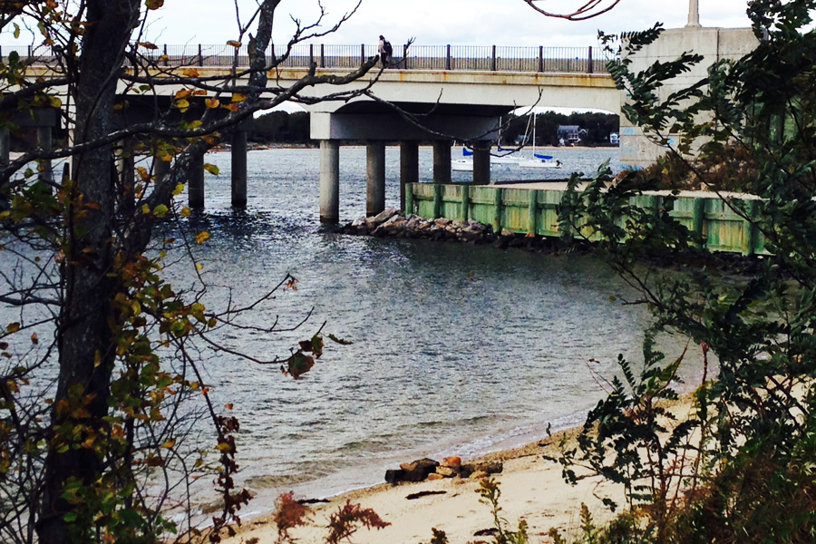
After hearing about this, because of a mention of it at a Village Board meeting, I took a walk to try to find this beach. I started at Windmill Beach and headed west, along the embankment that begins the rise up of the Lance Corporal Jordan C. Haerter Veterans Memorial Bridge to North Haven. The bridge is to your left, a lawn and the beach are to your right, with the bay beyond. When the bridge is high enough, instead of finding a dead end where the water goes under it, you find you can turn left and walk on a flat gravel area that takes you UNDER the bridge. Coming out the other side, to your left, there you are, at the arc of a beach just about the same size as Windmill Beach.
Whether this is a man made beach like Windmill Beach or not, I don’t know. What I do know is this. Standing on this beach, with your back to the land, it’s very clear why nobody knows about it. At your back are the backs of three commercial buildings, two of which are abandoned, as I show on the map on the previous page, and the third a building that houses the 7-Eleven facing onto a parking lot adjacent to Long Island Avenue. Who knew this was behind these buildings?
I had wondered if, walking the 100 yards or so to this beach, you had to return the same way you had come. But, having been told there’s a path you can take amidst the backs of the three buildings that lead you out to Long Island Avenue, I went to find it. I did find it, though I think I crossed private property.
But then I found something else. Just behind the foliage at the back of this hidden beach and running parallel to it, is an old concrete road. If you take it one way, it dead-ends at an abandoned dock there. But if you take it the other way, it ends nowhere. You are facing the ramp of the bridge. But it doesn’t reach it. What is this?
I looked around. If I walked past where it ends, I crossed a lawn that led to the pedestrian sidewalk of the bridge that would lead me down to the traffic melee and the curving building that houses Yummylicious. I would be back in the center of town.
I wondered about that old road. Who owned it, and who owned the beach, anyway? I went to the Village Municipal Building and looked at maps of the village lots. Here is what I found.
Every place I walked, other than when I walked on what I though was private property, is owned by taxpayers. The beach is owned by Sag Harbor Village. The parcel under the bridge is part of the bridge and is owned by the State of New York. The sidewalk leading down to Main Street and Long Island Avenue is Village and State owned.
Most interesting of all is that small concrete road parallel to the back of the beach that seems to go nowhere.
Guess what? How did you get to North Haven before there was a bridge? Why, you took a ferry. That old piece of concrete road had been the road to the ferry dock. It’s listed as such on the official maps. It must have been built hundreds of years ago. You came by horse down Route 114 from East Hampton, and just past where the roads come together at Long Wharf, 114 continues on but curves off to the left to end by that old abandoned dock and building still barely standing. What were they? That was where you and your horse and wagon waited until the ferry came back from North Haven “island.” You paid the ferryman, perhaps in shillings, and he took you to North Haven. When you were done, he took you back.
I owed this little walk to the imagination of landscape architect Edmund Hollander, who 15 years ago envisioned linking these two beaches with a walkway under the bridge. In the last few months, that project has re-emerged as a proposal to the Village by Bruce Tait, chairman of the Sag Harbor Village Harbor Committee. Tait believes that as a waterfront project in a small village, it would have a great chance to get State and Federal funding, and I agree.
For the cost of a walkway, which the Village could easily bear without extra funding, this project opens up all sorts of other possibilities.
1. The walkway connects two beaches a short walk from one another. It’s a lovely stroll, mirroring the one down Long Wharf and back.
2. It creates a way for pedestrian traffic to get from Main Street to Long Wharf and Windmill Beach without having to cross the street.
3. It creates what could be called a circular Whaler’s Walk, similar to Boston’s Freedom Trail. It starts at the old Fort Monument on High Street (from the War of 1812, where the cannon was), past the three churches, including the Old Whalers’ Church, down the hill to the John Jermain Memorial Library, across and past the Whaling & Historical Museum and the Customs House, down Garden Street, right onto Long Island Avenue, left at Main Street, along the sidewalk to the New Beach and the old ferryboat dock, under the bridge to Windmill Beach, Main Street and Long Wharf.
The commercial property where the two derelict buildings are today would now face out onto the beach there, the old Route 114 and the waterfront. This property is now owned by a group that presented a development plan this summer. This group would undoubtedly benefit. A waterfront commercial area much perhaps like Gosman’s could be developed there for sure. But that would be up to the Village Trustees to decide how and if.
Anyway, I’m for all of this. It would expand Sag Harbor right in the middle of town, where expansion belongs. And it would add to the excitement and history that makes Sag Harbor so special.

Vetted Hamptons Resources