Worst Traffic Ever: Foiled Attempts to Get Home Through Downtown East Hampton

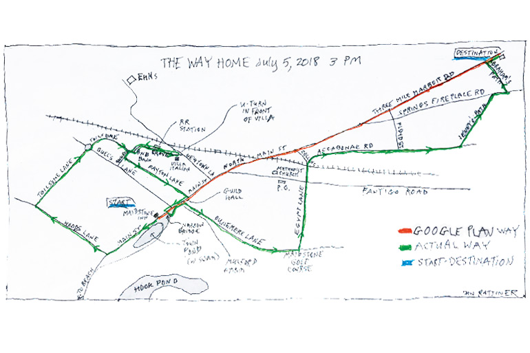
Thursday 3 p.m. July 5 departure: the Maidstone Hotel, East Hampton. Destination: 300 Three Mile Harbor Road in East Hampton.
Google Map directions: 3.4 miles, 9 minutes “Fastest Route despite the usual traffic. Turn left out of Maidstone Hotel, go down Main Street 1.1 miles to the traffic light. Just beyond it, bear left onto North Main Street, go under railroad trestle 0.5 miles, bear left onto Three Mile Harbor Road, drive 2 miles and your destination will be on the right.”
The rest of this essay is a tribute to the robot who firmly and patiently persisted in interrupting our journey to return us to the preferred route. Her steadiness and quiet determination is a testament to robots everywhere. Nevertheless, her comments, frequently interrupting our journey, have been removed from the trip diary. It disrupts the diary annoyingly.
Trip Diary: Unwilling to make a left out of Maidstone Hotel because traffic is at a standstill in that direction eastbound, we instead make a right heading away from our destination. After .1 mile driving alongside Town Pond with a white swan in it looking us over, we turn right onto Woods Lane and drive .3 miles under the overarching elms along that road to the traffic light at Toilsome Lane and make a right. We proceed down to the new roundabout at Buell Lane, go around it and continue on Toilsome Lane making the right ninety-degree turn to the end of that road at the stop sign at Race Lane next to the BNB Bank.
At that stop sign, we turn 90 degrees to the left one block, turn right onto Railroad Avenue, go past the railroad station toward the stop sign where normally you can only make a right turn onto Newtown Lane, look right and see all traffic is stopped up all the way down Newtown Lane and look left to see traffic is further backed up in that opposite direction toward the high school.
Alarmed, rather than make the right into that mess, we look both ways and make an illegal U-turn right there in front of the Villa Italian store, to head back the way we came on Railroad Avenue, past the railroad station, to make the left onto Race Lane, go one block the other way to the stop sign at the BNB bank, turn right onto Toilsome, then an almost immediate left turn onto Church Lane. We proceed one block down that street and make a left at Dayton Lane.
Dayton Lane takes us back to Main Street one and a half blocks east of where we started at the Maidstone Hotel. Here, we again observe the gridlock on Main Street going east into the center of town, and so once again turn right heading west back toward Woods Lane, but before getting there, make the left across the narrow bridge crossing Town Pond’s eastern end, zigzag onto the start of Dunemere Lane between Mulford Farm and Guild Hall and head south for .2 miles until it ends at Egypt Lane. There, in what seems to be the middle of the Maidstone golf course, we make that left onto Egypt Lane and head back into town to where Egypt Lane ends at the Pantigo Road traffic light.
The Post Office is on our left, the Methodist Church across the way. We observe Montauk Highway traffic is gridlocked westbound at the Pantigo light and is even blocking our desire to cross it. We make hand signals to what seems to be a friendly motorist in that gridlock, beg for permission to get a way through onto Accabonac Road (reluctantly granted) and then head north. It is just 100 yards to get under the railroad trestle.
Traveling under the railroad trestle with left blinker on intending to turn onto that one block-long road that connects up to North Main Street on the western side of the IGA, in order to turn right onto North Main Street, we see that traffic is gridlocked on this one block road. It’s impossible. It’s not only gridlocked its entire one-block length to where we hoped to get onto it, but it’s also gridlocked back up onto the westbound lane of Accabonac Road, where folks are waiting to make that turn.
Seeing the eastbound lane of Accabonac is all open, however, we turn off the blinker and instead continue straight ahead eastbound further down Accabonac, past the Floyd Street left turn—I believe it’s a one-way street somewhere in there the other way—and so proceed to Jenny’s Path, where we turn left and take it to the end where it meets up with Springs-Fireplace Road, where we turn right, go past the dump, the sand and gravel place and then after the One Stop Market shopping center turn left onto Abraham’s Path and take that to the end, turn right onto Three Mile Road and voilà, just a thousand feet down, we arrive at our destination.
Actual distance: 21.3 miles. Elapsed time: 42 minutes. Blood pressure on arrival: 170 over 90.


