Planning The Future Of Springs Corridor


Dozens of East Hampton Town residents joined town planners, outside consultants, and assorted town officials for an open meeting regarding the long-term approach to the area known as the Springs corridor.
The corridor is somewhat triangular, starting where North Main Street forks into Springs Fireplace Road and Three Mile Harbor Hog Creek Road, which forms the western border of the corridor. The northern border is Abrahams Path, with the eastern border being Accabonac Road south to Floyd Street, then west to Springs Fireplace Road, and south to the fork in the road at North Main Street.
The meeting at the East Hampton Library February 27 began with presentations by outside consultants Ray DiBiase of the engineering firm L.K. McLean Associates, PC; Peter Flinker of Dodson & Flinker; and Lisa Liquori, a former head of the town’s planning department, who has been shepherding a series of hamlet studies conducted by the town over the past couple of years.
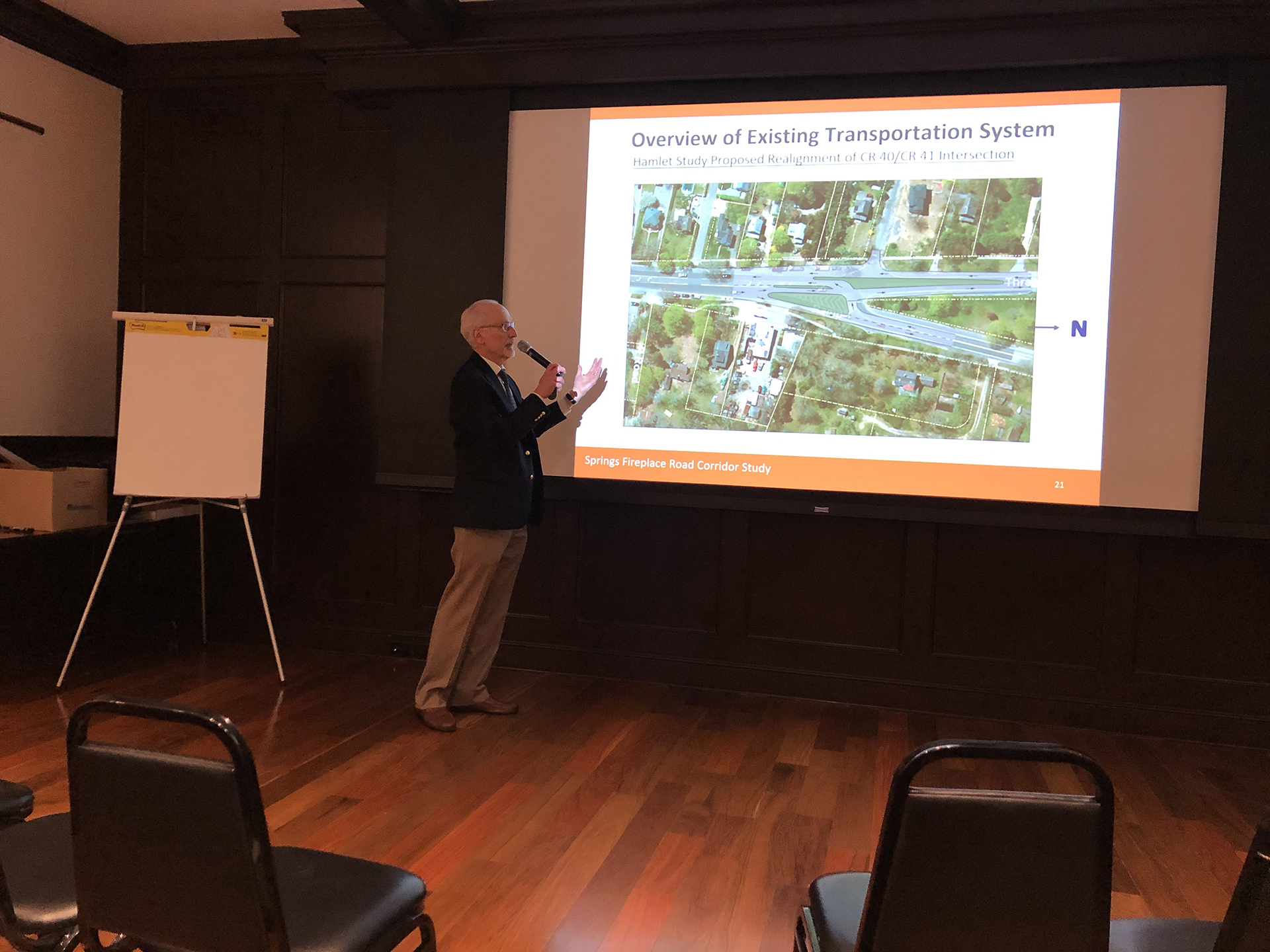
One major change on the horizon involves the intersection where North Main Street forks to the north, becoming both Springs Fireplace Road and Three Mile Harbor Road. DiBiase led that discussion during his initial presentation.
Currently, he said, traffic headed south on Springs Fireplace Road comes to a halt at the intersection. For a driver to continue south onto North Main Street, he or she must cross traffic on Three Mile Harbor Road.
Making things more difficult for southbound drivers is that people often do not signal whether they are going to veer left onto Three Mile Harbor or right onto Springs Fireplace Road. Further exacerbating the issue, DiBiase said, some drivers, especially those unfamiliar with the intersection, will realize they meant to bear right onto Springs Fireplace Road, and will veer across the road at the last moment. During the summer, DiBiase said, this dangerous situation can cause southbound traffic to back up a good distance on Springs Fireplace Road as drivers wait.
The ideal solution, he said, would be a roundabout. The problem with that solution is that the land immediately to the north, a small portion of which would have to be included in the roundabout, is preserved land. To use that land, state legislation would be needed, which is not an easy task, DiBiase said.
Instead, the proposal the town is considering would create a triangular island that would force northbound drivers to choose which road they want sooner. The southbound Springs Fireplace Road drivers would turn right north of that island, which DiBiase said would be landscaped. Under the proposal, those drivers headed south on Springs Fireplace Road would only have to contend with those drivers headed up Three Mile Harbor Road.
When the coast is clear, the southbound drivers would turn into a lane separate from the southbound Three Mile Harbor Road traffic. Those two lanes would then merge into one.
While this proposal was given the most time during the initial presentation, all matters from traffic to pollution were, quite literally, put on the table. When the consultants finished their presentations, giant maps of the corridor were spread out on five tables in the Baldwin Room, each supplied with markers, with participants encouraged to demarcate their ideas and suggestions.
“Over 50 residents and property owners participated in the charrette identifying conflict points, elements in the corridor that need protection, as well as opportunities we need to explore,” said East Hampton Town Board member Kathee Burke-Gonzalez, who is overseeing the corridor planning process. “The more town officials and our consultants understand how this corridor functions for all of the different constituencies, the better and more actionable the final recommendations will be.”
t.e@indyeastend.com


