Update: Tropical Storm Warning in Effect for East End


Update, August 3, 3 PM: Suffolk County Executive Steve Bellone urged residents to make preparations now for Tropical Storm Isaias, which is expected to make landfall on Long Island. A tropical storm warning was issued early Monday island-wide.
Tropical storm-force winds of 39 to 55 mph and gusts of up to 65 mph are in the forecast for Tuesday and Wednesday. Heavy rain of 2 to 3 inches — 1 to 2 inches here on the East End — will start Tuesday afternoon.
The storm will also bring dangerous surf of 10 to 15 feet and rip currents.
Coastal flooding will depend on the track and intensity of the storm, Bellone said. Residents in areas prone to flooding should brace for the potential of 2 to 3 feet of flooding as it coincides with Tuesday night’s high tide, between 9 p.m. and midnight.
Bellone urged residents to sign up for Code Red, a high-speed notification system, that allows the Department of Fire Rescue Emergency Services to send out important information quickly to residents.
Bellone said this storm is “different in the sense that it is coming in the throws of the global pandemic.”
“It may turns out that the track of this storm ultimately produces minimal impacts for residents here in Suffolk County. If that does turn out to be the case, that’s a good thing, we’re very happy about that, but what this storm does become then is essentially a dry run for what is to come, for what could be a very active hurricane season.”
Update, August 3, 7 AM: A tropical storm warning is now in effect for the tri-state area as Isaias makes its way up the coast. It is expected to reach our area in the next 36 hours.
The National Weather Service is still calling for winds of 35 to 5 miles per hour with gusts up to 65 mph on Tuesday afternoon through Wednesday morning.
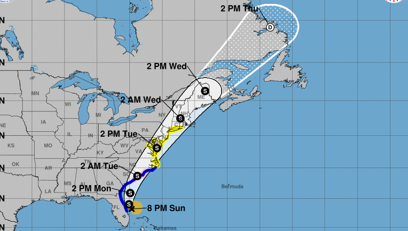
Originally, August 2: Tropical Storm Isaias is expected to bring tropical storm-force winds and heavy rainfall to the East End early this week. The National Weather Service issued a tropical storm watch for the tri-state area on Sunday evening.
On Sunday night, Tropical Storm Isaias was located off the coast of Florida and expected to turn north. Forecasters say it will weaken slowly as it accelerates and go to the northeast over the Carolinas Tuesday morning. Additional watches and warnings will likely be issued Monday as Isaias moves northward near or over the mid-Atlantic and New England states Tuesday and Wednesday.
While there are still uncertainties about its timing and intensity when it hits the tri-state area, the storm will likely bring 35 to 45 miles per hour winds with gust up to 60 mph from Tuesday afternoon until early Wednesday morning.
Heavy rainfall of 2 to 4 inches — up to 6 inches locally — could start Monday night.
“There is a moderate potential for coastal flood inundation of 1 to 2 feet above ground level, with a low potential for up to 3 feet, for the most vulnerable shoreline and coastal locations,” the weather service said.
Dangerous marine conditions are likely with high surf and dangerous rip currents at ocean beaches Monday through Wednesday.
Iasias will move out of the area quickly late Tuesday night into Wednesday morning.


