Hitler Hills: An Unfortunate Typo or a Conspiracy in Montauk?

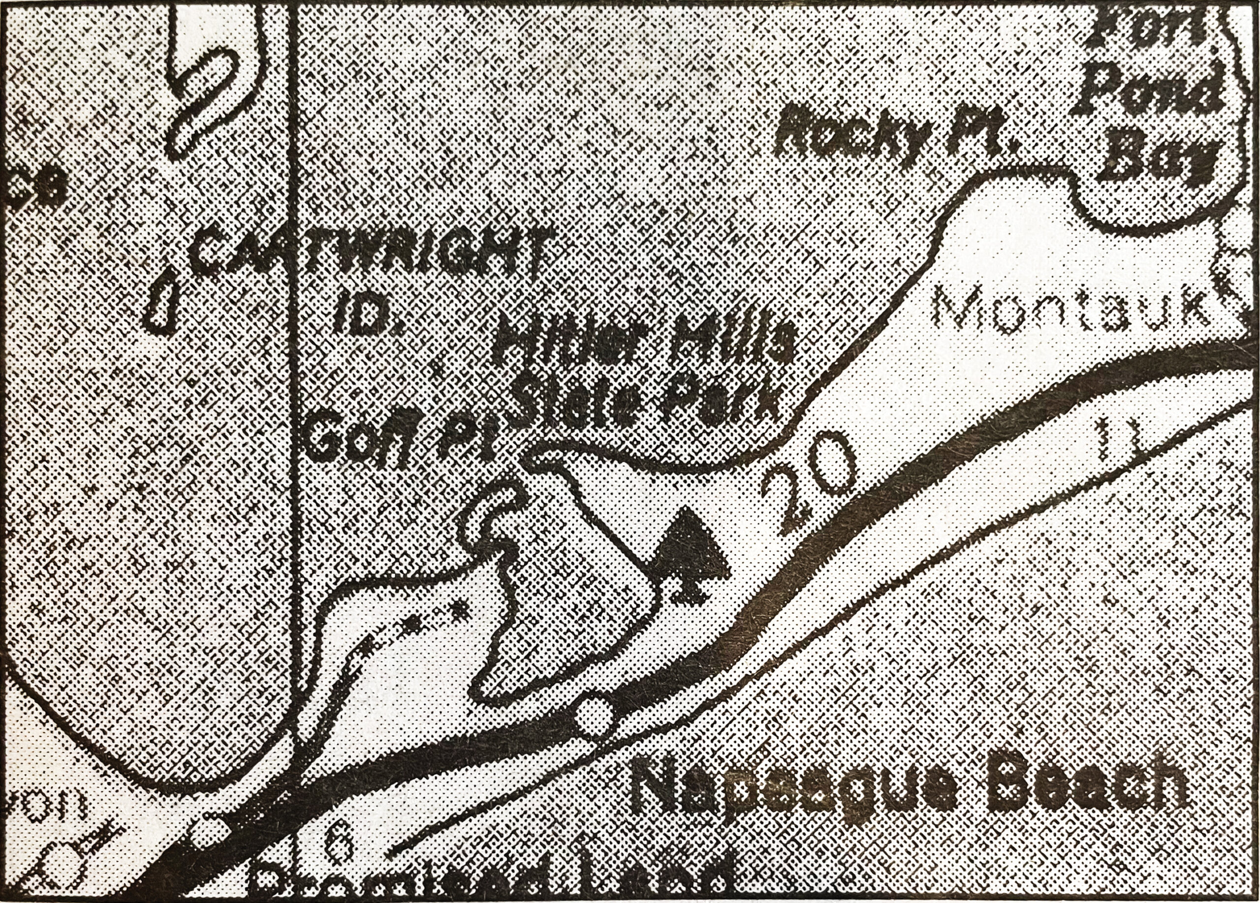
I have a map of eastern Long Island which, among other things, indicates the location of the Hitler Hills State Park in Montauk. Yes, Hitler Hills. Not Hither Hills. The map was given to me as a gift by Howard and Karen Owen, who some years ago stopped by the Dan’s Papers office with it.
On vacation in Fredericksburg, Virginia, they had shopped at an antique store and had purchased this map, which accurately showed the roads and features of eastern Long Island. Or so they thought.
They had a summer home here. Well, this was an old map, published in 1940 by the Quaker Oil Company. It would have been something given to you for free when you stopped at their gas station to fill your tank. Free maps were available at gas stations back then.
And, somehow, this one had come to be at an antique shop in Fredericksburg, the town where Confederate General Robert E. Lee set up his last stand in the Civil War before surrendering to Union Army Commanding General Ulysses S. Grant at Appomattox — leading to the end of slavery.
But what was this? Hither Hills on this map was called Hitler Hills.
Who would have made this mistake in drawing this map? Well, 1940 was a pivotal year in America.
The year before, Hitler’s armies had invaded Poland. France also fell in 1940 and hundreds of thousands of English troops were temporarily trapped at Dunkirk. But the attack on Pearl Harbor had not yet happened, so in 1940, the U.S. was not yet at war.
Indeed, many Americans, particularly German-Americans, still considered Hitler a fine fellow. In 1938, in nearby Yaphank, Nazi leaders on Long Island had hosted Camp Siegfried to celebrate Hitler and Nazi power. It included rallies, torch-led marches, speeches and bonfires.
Another Nazi rally filled Madison Square Garden in 1939. Germany would soon rule the world.
Hither Hills in Montauk had been created as a state park 15 years earlier, in 1924. That year, Robert Moses, who built many of the parks and highways on Long Island, set aside land in Montauk for that purpose — calling it Hither Hills State Park. It is there today, 1,755 acres in size, on the ocean as a tent camp and beach for visitors, and inland as undeveloped parkland.
Then came this map in 1940, with this error.
Or was it an error? Perhaps there was an enthusiastic Nazi sympathizer in America working as a mapmaker who did this.
Well, the Japanese attacked Pearl Harbor in Hawaii on December 7, 1941, then the United States declared war against Japan and Germany. And six months after that, four uniformed German saboteurs brought explosives ashore from a rubber raft launched from a Nazi submarine near Amagansett.
Their goal? Blow up factories, bridges and railroad tracks to bring America to her knees. The saboteurs, in the dark of night, took off their uniforms, donned fishermen’s clothes, buried their explosives, walked inland and, with the leader carrying a satchel consisting of about a million dollars in today’s money, boarded a train at the Amagansett station and went to New York City.
George Dasch, their leader, had emigrated to New York years earlier, knew that city well, and also knew the Hamptons, having worked summers as a waiter there.
A few days after landing, however, he traveled to Washington, D.C. and turned the other saboteurs in to the FBI. They all were electrocuted, except the leader, Dasch, who got a long prison term.
A speculation: Did that leader, meeting earlier with Hitler at a saboteur school in Germany to discuss the upcoming sabotage operation, show his leader a copy of that 1940 road map where the saboteurs might land? Hitler Hills? It might have raised a dictator’s eyebrows.
And something else interesting: The streets in what had been Camp Siegfried, and later became a residential development, were still named after various Nazis. But then the names were changed.
Here is what else happened at Hither Hills in 1940.
That year, a New York City newspaper, the New York Daily Mirror, advertised free rides to Montauk just east of Hither Hills State Park to push sales of $100 lots in Hither Hills Mirror Development. For just $100, you could buy a lot suitable for the building of your summer home.
These lots were tiny, just 1/10th of an acre. And there were hundreds of them. On paper, the developer had indicated where roads would someday be built to give access to all these lots. Indeed, later, they were built. They are the series of roads in this area today named after Presidents. Lincoln, Grant, Taft, Tyler, Coolidge, Washington, Monroe.
And all these lots would come with exclusive rights to the nearly two miles of undeveloped beaches across the Old Montauk Highway that borders this development.
In any case, that 1940 promotion was considered a failure. No homes were built at that time. But after the war, the roads were put through and summer homes did get built. And today, this section of Montauk is known as “Hither Hills,” probably just because it is next to the Hither Hills State Park.
A confession: I made a killing at Hither Hills. I bought two lots on Grant Avenue for $2,500 in 1972 and in 1977, happy to almost double my money, sold them for $4,500. Today, with their rights to the beach across the street, they sell for millions. Oh, if only I had held on.
Hitler Hills. A map with a story.


